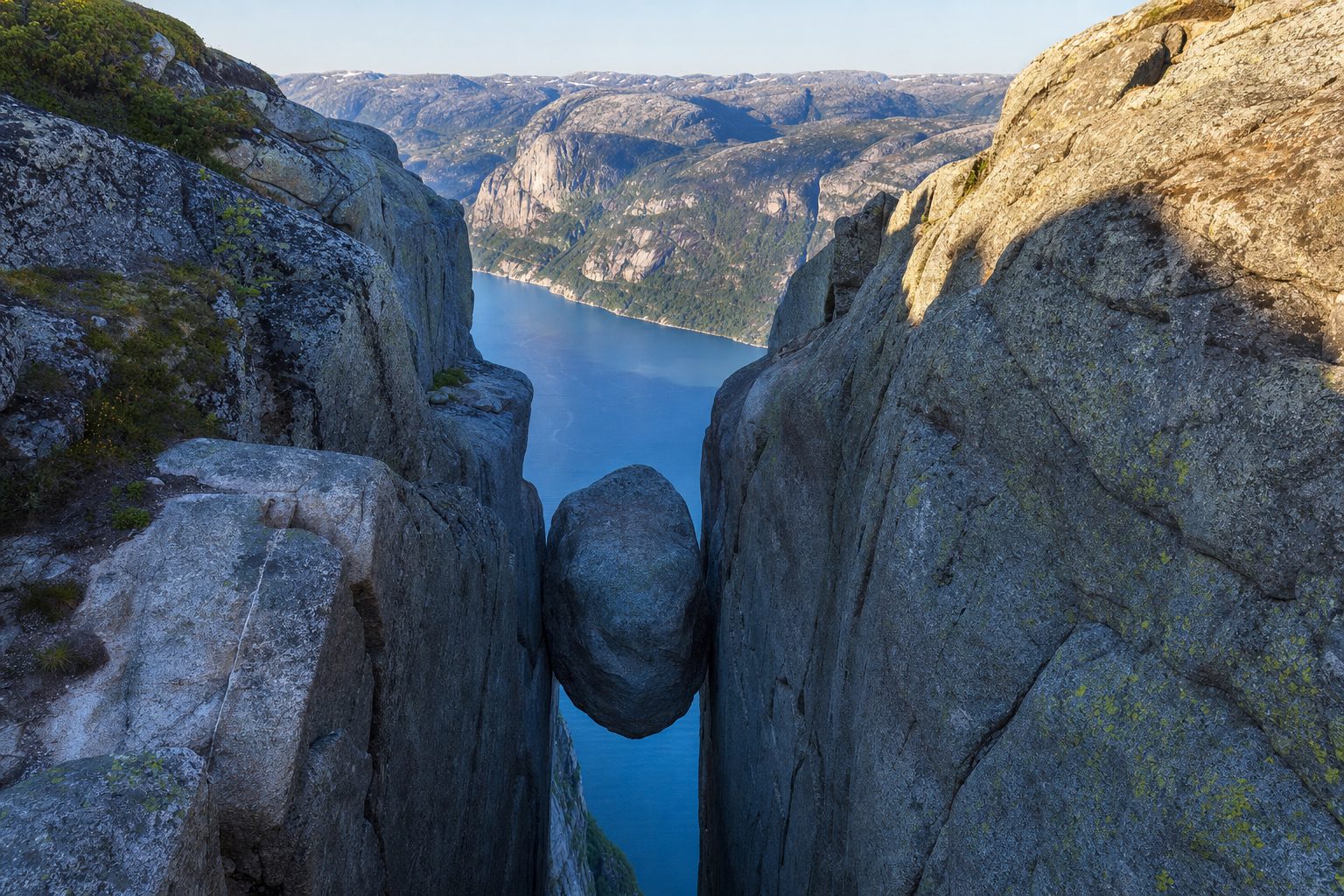
Kjeragbolten looks like a dare: a rounded glacial boulder jammed into a crevice roughly 1,000 metres above the Lysefjord, with nothing beneath it but air and dark water. What the photographs rarely explain is that the boulder sits at the far end of a genuinely hard mountain hike, and that the whole experience runs on a clock. Each autumn, when the first serious snow arrives, Norway closes the mountain road to the trailhead — and the safety chains bolted to the steepest granite slabs come down with it. From roughly late October or November until mid-May, Kjerag is effectively shut to ordinary hikers.
That seasonal deadline shapes every other decision. Before you commit, you need to settle four questions: whether the hike itself is within your ability, how you will reach the remote Øygardstøl trailhead, how early you must start, and — only at the very end — whether you will actually step onto the boulder. This guide works through each in turn, in the same spirit as our Preikestolen guide further down the same fjord.
What the Kjerag hike actually involves
The walk to Kjeragbolten starts at Øygardstøl, a car park and viewpoint perched about 640 metres above the village of Lysebotn at the innermost end of the Lysefjord. From there the route crosses three successive ridges: a steep climb over the first, a descent into the little valley of Litle Storedal, a second stiff pull, and finally a long ridge up onto the Kjerag massif itself, with the fjord falling away below. The rock is bare granite for long stretches, and on the steepest slabs several hundred metres of chains are bolted into the mountain so that hikers can haul themselves up and steady themselves on the way back down.
None of this is climbing in the technical sense, but it is emphatically not a stroll. Visit Norway describes the route as demanding even for experienced hikers, and the granite becomes slippery the moment it rains. The trail is marked with the red T of the Norwegian Trekking Association (DNT), parts of it have been paved with stone steps, and mobile coverage is patchy — reasonable on the open ridge tops, poor or absent at the boulder itself and in the valleys between. There are no toilets and no huts along the way, only an emergency shelter on the second ridge that is reserved for genuine emergencies. If you found Preikestolen comfortable and want the next step up in seriousness, Kjerag is the natural progression; if Preikestolen felt like your limit, treat that as useful information.
The return hike from Øygardstøl to Kjeragbolten is around 11 kilometres with roughly 800 metres of total ascent, and Visit Norway advises allowing six to ten hours for the round trip in rough, partly chain-assisted terrain. [1]
The October deadline: chains, snow and a closed road
The hook that brings most people here — that Norway takes the chains down in autumn — is true, and it is worth understanding the mechanics. Kjerag sits at over 1,000 metres, in a landscape that holds snow late into June and can see fresh snowfall again by late September. The county road between Sirdal and Lysebotn, which serves the trailhead, closes with the first proper snowfall, usually in October or November, and normally reopens around mid-May once the ploughs have cut through snow walls that can stand several metres high. The official season for the hike runs from May to October inclusive.
Outside that window, Kjerag does not become forbidden so much as inaccessible and unprotected: with the road shut there is no ordinary way to reach Øygardstøl, and the fixed chains on the slabs are gone. The regional tourism board is blunt that winter attempts are not recommended and that anyone travelling outside the season should go with experienced guides, on skis or snowshoes, with full winter equipment. In practical terms, if your travel dates fall between November and mid-May, this is not your hike — plan for Trolltunga or Preikestolen in their respective seasons instead, or book a guided winter alternative elsewhere in the fjords.
Fjord Norway states that the chains along the Kjerag trail are removed when the Sirdal–Lysebotn road closes for winter — usually with the first snowfall in October or November — and are reinstalled shortly after the road reopens around mid-May. [4]
Getting to Øygardstøl: 27 hairpins, a bus or a ferry
Øygardstøl is spectacularly remote by road. Driving from Stavanger takes around three hours via Sirdal, finishing along Lysevegen (county road fv. 500), a narrow seasonal mountain road that descends towards Lysebotn through 27 hairpin bends and more than 900 metres of vertical, including a corkscrew tunnel cut inside the mountain. The trailhead car park sits at the top of the bends, so drivers coming from Sirdal arrive without descending to the fjord at all. The road demands patience: it is narrow, busy with motorhomes in summer, and closed entirely outside the season, usually from November until late May.
Without a car, the practical option is the Kjerag Express bus run by Go Fjords from Stavanger bus terminal. It is designed around the hike: an early departure, roughly three hours to Øygardstøl, six hours at the trailhead, and a return that gets you back to the city in the evening. Six hours is enough for a fit party in good weather, but it leaves little slack, which is one more argument for moving efficiently and skipping long breaks on the way out. The slower, more scenic route is to take the tourist ferry or express boat from Stavanger up the full length of the Lysefjord to Lysebotn, then a shuttle bus or taxi up the hairpins to the trailhead; Fjord Norway recommends booking boat tickets well ahead in high season.
As checked in September 2026, the Kjerag Express bus runs June to September, departing Stavanger at 07:45 and returning from Øygardstøl at 16:30 — weekends only in June and September, plus Tuesdays and Thursdays in July and August — giving hikers six hours on the trail. [5]
Parking, fees and what awaits at the trailhead
The trailhead is better equipped than its wilderness setting suggests. Kjerag Parking is run by Lysefjorden Utvikling, a non-profit that channels fees back into trail and facility maintenance, and holds up to 400 cars across two areas — it rarely fills, even in July. There are toilets, a staffed tourist information office with daily trail and weather updates, free Wi-Fi, and the Eagles Nest café building on the cliff edge overlooking Lysebotn. Staff will tell you frankly whether conditions are fit for the hike that day, and you can even rent boots, waterproofs and poles on the spot if your own gear falls short. Note one firm rule: sleeping in vehicles at the car park is prohibited, with camping directed down to Lysebotn instead.
As checked in September 2026, parking at Øygardstøl costs 300 NOK for stays over two hours (a short viewpoint stop under two hours is 30 NOK), payable at the machine after the hike; the car park operates around the clock from mid-May to the end of October. [3]
Stepping onto the boulder — or not
The boulder itself is the last five metres of the day, and it deserves a clear-eyed decision rather than peer pressure. Reaching it involves a short, exposed shuffle down sloping rock to where the boulder sits wedged between the cliff walls; there is no fence, no harness point and no attendant. The step onto the top is short but the penalty for a slip is absolute. The official guidance is unambiguous: going out onto Kjeragbolten is entirely at your own risk, and you should not attempt it if the rock is wet or icy, if it is very windy, or if you feel any vertigo at all. Queues form at the boulder on fine summer weekends, which at least gives you time to watch others and make an honest assessment.
There is no shame in declining. Around 45 per cent of hikers who reach the plateau choose not to stand on the boulder, and the five-minute side trip to the Nesatindane viewpoint — its turn-off roughly 300 metres before the boulder — arguably offers the better panorama: the full 42-kilometre run of the Lysefjord, and in summer the sight of base jumpers launching from the opposite cliffs towards the landing ground at Geitaneset far below. The plateau, not the boulder, is the actual summit experience.
Standing on the boulder is optional and entirely at your own risk: never attempt it when the rock is slippery from rain, snow or ice, or in strong wind, and never run or jump when getting on or off.
— Paraphrased from the official Kjerag visitor site (kjerag.info)
When to go, and what the mountain expects of you
Within the May-to-October season, the sweet spot is late June to early September, once the lingering snowdrifts have melted off the slabs and before the autumn rains set in. July and August bring the most reliable weather and the biggest crowds; June and September trade some certainty for quieter chains. Expect conditions on the plateau to run about ten degrees colder than Stavanger, with stronger wind, and treat fog as a hard stop — the plateau edges are unfenced and the route onto the boulder should never be attempted blind. Check the forecast for Kjerag itself on yr.no rather than for the fjord villages below, and ask the trailhead staff before starting.
- Proper hiking boots with ankle support — the route is bare granite, and trainers are the most common cause of trouble on the chains.
- Windproof and waterproof shell plus a warm layer, hat and gloves, even in July: the plateau sits above 1,000 metres.
- More food and water than feels necessary, and a headlamp in case the descent runs late — there is nowhere to resupply after Øygardstøl.
- A paper map or downloaded offline map: mobile coverage fails at the boulder and in the valleys.
- Cash-free payment for parking and rentals; the fee is settled at the machine after the hike.
A few points of etiquette are enforced in spirit if not by wardens. The trail crosses working sheep pasture, so dogs stay on a lead and the animals are left alone. Drones are not permitted in the area. Everything you carry in comes back out with you — there are no bins beyond the car park — and the emergency shelter on the second ridge is not a picnic hut. Norway's mountain rescue volunteers retrieve unprepared hikers from these hills every year; the aim is not to meet them.
Kjeragbolten rewards the traveller who respects its calendar: pick a date inside the chains-up season, start early, and let the weather — not the photograph — make the final call at the boulder. If this trip is part of a longer Norwegian itinerary, it pairs naturally with Preikestolen on the same fjord, and a few days further north the Geirangerfjord shows the gentler, ferry-and-viewpoint side of the same landscape. For more ideas at this end of the difficulty scale, see our adventure travel bucket list.
Sources & further reading
- 1. Visit Norway — hiking to Kjerag (official national tourism board)
- 2. Kjerag 365 — hiking to Kjerag (official visitor site)
- 3. Kjerag 365 — parking at Kjerag (official visitor site)
- 4. Fjord Norway — Kjerag national scenic hike (official regional tourism board)
- 5. Go Fjords — Kjerag Express bus from Stavanger (operator)
- 6. Visit Norway — Lysevegen road in Lysebotn
- 7. Lysefjorden 365 — Kjerag (official Lysefjord visitor site)