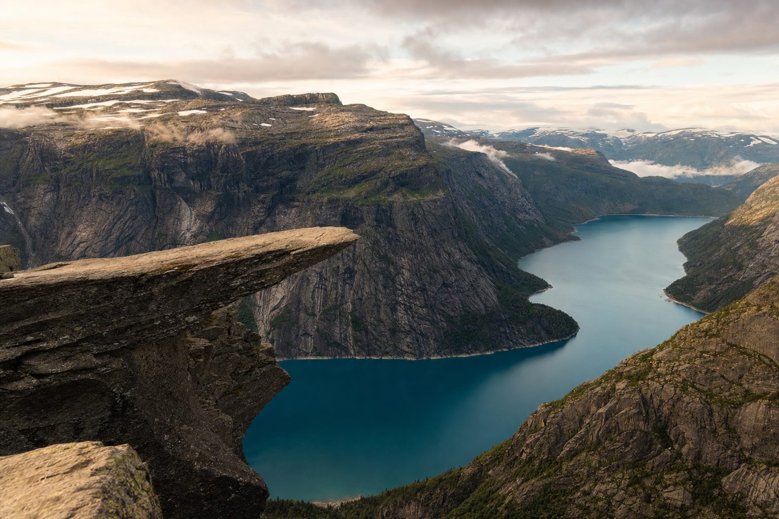
Trolltunga looks effortless in photographs: a flat blade of granite hanging some 700 metres above the blue-green water of Lake Ringedalsvatnet, one person standing at its tip. The walk that earns that photograph is anything but effortless. From the main trailhead it is a 27-kilometre round trip through high-mountain terrain above Odda and Tyssedal in Norway's Hardanger region, officially graded Very Demanding, and most hikers need eight to twelve hours to complete it.
The clip that probably sent you here makes a simpler claim: after 11am, no one starts this hike. That is close to the truth, and understanding why organises every other decision. The 11:00 cut-off is real — it is when the entry window at the highest car park closes and when the last morning shuttle leaves for the upper trailhead — but the deeper logic is daylight arithmetic on a very long day out. This guide works through the choices in order: which of the three trailheads to start from, when to set off, how the shuttles and parking bookings work, and what the ledge itself is actually like.
What the hike actually involves
Trolltunga sits at about 1,180 metres above sea level on the western edge of the Hardangervidda plateau. From P2 Skjeggedal, the main trailhead, the route climbs steeply out of the valley — the opening kilometres are the hardest of the day — then rolls across open mountain terrain of bare rock, lakes and streams, marked with red T symbols, before narrowing towards the ledge. There is no forest cover and no shelter from weather for most of the route, and the official trail authority grades any hike over 20 kilometres as Very Demanding by definition.
From P2 Skjeggedal the round trip is 27 km with roughly 800 metres of ascent, estimated at 8–12 hours; from P3 Mågelitopp it shortens to 20 km with about 320 metres of ascent, estimated at 7–10 hours. [2]
Those hour ranges are honest, not padded. The descent is the stage that catches people out: the mountain rangers note that many accidents happen on the way down, when hikers are tired, and the bare granite becomes slippery in rain. Fitness matters less than endurance — this is a long day of continuous walking on rock rather than a technical climb — and the trail itself is solid, well maintained and clearly marked. If you have done a big single-day mountain walk before, such as Preikestolen further south on Lysefjord, Trolltunga is that experience roughly tripled in length.
The 11am rule, decoded
The rule readers arrive with is worth stating precisely, because it is really three separate mechanisms. First, entry to P3 Mågelitopp — the high car park that shortens the hike — is limited to a morning window. As checked in September 2026, the operator admits pre-booked vehicles between 6:30 and 11:00 from June to August, and between 7:00 and 11:00 in the first half of September; later in September, remaining spaces are sold at the ticket booth at Skjeggedal, weather permitting. Second, the last shuttle bus of the morning from P2 up to P3 departs at 11:00 before a midday break. Third, and more fundamentally, an 11:00 start from P2 puts a slower party's return after dark for much of the season.
As checked in September 2026, entry to the P3 Mågelitopp car park is 6:30–11:00 from June to August (online booking required) and 7:00–11:00 in early September; parking costs NOK 600 per day with capacity for 30 vehicles. [6]
In practice, treat 11:00 as a hard ceiling and aim much earlier. Visit Norway's official advice is to start before 8am to be sure of getting back in daylight, and the busiest window at the ledge itself is 12:00 to 15:00 — so an early start buys you both a safety margin and a shorter photo queue. Hikers who want the ledge nearly empty either start at first light or carry camping gear and sleep on the plateau under Norway's right to roam, well back from the formation itself.
P1, P2 or P3: choosing your trailhead
Three car parks stack up the mountainside, and the choice sets the shape of your day. P2 Skjeggedal (415 metres above sea level, 229 spaces) is the default: the full 27-kilometre round trip with about 800 metres of ascent, no advance booking, pay at the machine on arrival. P3 Mågelitopp (860 metres, 30 pre-booked spaces) lops the steepest climb off both ends, cutting the day to 20 kilometres and, by the operator's estimate, saving around three hours. P1 Tyssedal (144 metres, 227 spaces, NOK 330 for the day as checked in September 2026) is best understood as overflow and motorhome parking with a shuttle connection — hiking from P1 itself is a 38-kilometre epic the official site estimates at 15 hours, which almost nobody should attempt in a day.
Note the road rules between the tiers. Skjeggedalsvegen, the narrow road from P1 Tyssedal up to P2, carries a NOK 220 toll that applies to every vehicle including rentals and AutoPASS holders, bans vehicles over 5.2 metres, and — following recent rockslide-protection work — was open to traffic only between 6:00 and 21:00 daily as checked in September 2026. The final road from P2 to P3 is stricter still: only shuttle buses and cars with a valid P3 reservation may drive it, and going up simply to drop passengers is not permitted. If P3's 30 places are gone, the honest alternatives are the shuttle or the full walk from P2 — the toll and parking income, the trail authority notes, funds the trail, the rangers and the rescue shelters.
No car? Odda and the shuttle buses
Odda, the small industrial town at the head of the Sørfjord, is the practical base, with Tyssedal a few kilometres up the fjord. Shuttle buses run from Odda to P1 and P2 — about 30 minutes to Skjeggedal — and a separate shuttle continues from P2 up to P3 Mågelitopp. As checked in September 2026, the Odda–Skjeggedal shuttle was scheduled from mid-May to late September and the P2–P3 shuttle from 8 June to 30 September, weather permitting, since the upper road closes in snow or ice. Seats are limited on all of them and the official transport pages urge booking ahead rather than gambling on boarding.
Season, weather and what to carry
The self-guided season runs from 1 June to 30 September; for the rest of the year the trail authority recommends going only with a guide, and winter trips become genuine expeditions on snowshoes or skis. The season's edges are soft: snow can linger on the plateau into late June in some years, and fresh snow can settle from mid-October or earlier. September brings sharply shorter days — the strongest argument of all for an early start — while July and August bring the crowds. Whatever the month, it is always colder up on the plateau than down by the fjord.
The weather in the high mountains can change suddenly: check the forecast before you set out, and never attempt the hike to Trolltunga in strong wind, heavy rain or fog.
— Paraphrased from the Trolltunga official website's hiking guidance
- Sturdy hiking boots with ankle support — the route is bare granite, boulders and stream crossings, not a gravel path
- Windproof and waterproof shell plus warm layers, hat and gloves, even in July
- Food for a 10–12 hour day and at least two litres of water; streams along the route are refillable
- Headlamp, fully charged phone and a power bank — mobile coverage works along most of the trail
- Map and compass as backup; red T markers guide the route but fog can hide them
The safety net on the mountain is unusually good for Norway, and it exists because Trolltunga's fame outran its infrastructure a decade ago. A staffed mountain-ranger cabin, parking attendants who check that hikers are dressed and provisioned, upgraded trails and better mobile coverage have cut rescue operations drastically from the 42 recorded in 2016. None of that changes the basic contract: you carry what you need, you turn back if the weather turns, and the emergency number is 112.
Three emergency shelters — Floren, Endåen and Tyssehøl — stand along the trail, stocked with sleeping bags, blankets and emergency supplies, and the mountain-ranger cabin is staffed around the clock from about 17 May to mid-October. [5]
On the ledge: the queue and the edge
There is no fence, gate or railing at Trolltunga. The ledge projects roughly ten metres out from the cliff face, the drop to the lake is about 700 metres, and access is a short climb down four iron rebar steps. In high season a queue forms for the photograph — typically 30 to 45 minutes on weekdays and 60 to 90 minutes on Saturdays, with a ranger walking out around midday to keep it orderly. The etiquette is simple and enforced by the queue itself: a few poses, then yield. Early morning and late afternoon see little or no queue at all.
Visitor numbers at Trolltunga grew from about 800 in 2010 to roughly 80,000 hikers annually, and the trail is busiest in July and August, especially between 12:00 and 15:00. [4]
Treat the edge on its own terms. The official guidance is to stay at least a couple of feet back from the rim when waiting, to keep well clear in wind or fog, and to skip the ledge entirely in poor visibility — the platform is wider than photographs suggest, but a fall would be fatal and there is nothing to catch you. Drone pilots must register with Avinor and must not fly when people are out on the rock. None of this is meant to talk you out of the walk; it is what doing it right looks like on a formation that has, remarkably, seen only one fatal fall despite its traffic.
Where Trolltunga fits in a western Norway trip
Give it two full days if you can: one for the hike and one in reserve, because the forecast rules the mountain and a spare day doubles your odds of a clear ledge. Odda also sits within easy reach of the Hardangerfjord's orchards and waterfalls, and pairs naturally with a longer fjord itinerary — Geirangerfjord and its ferry-and-viewpoint circuit lies a day's drive north, while hikers chasing more Norwegian granite can look to the Lofoten Islands or build the whole trip around the country's big walks alongside our adventure travel bucket list. Whichever way you route it, the Trolltunga rule stands: book the parking, watch the sky, and be walking long before 11am.
Sources & further reading
- 1. Trolltunga official website — The hike to Trolltunga
- 2. Trolltunga official website — Parking (P1, P2, P3)
- 3. Trolltunga official website — Shuttle buses
- 4. Trolltunga official website — Seasons
- 5. Trolltunga official website — Mountain rangers and emergency shelters
- 6. Trolltunga Norway (P3 Mågelitopp operator) — Parking and entry times
- 7. Visit Norway — Hiking to Trolltunga
- 8. Arctic Norway Tours — Trolltunga hiking guide